Woojin Jung, Assistant Professor at the Rutgers School of Social Work, and RUCI Lab Faculty Affiliate, is focused on utilizing geospatial data analytics, with a particular emphasis on poverty alleviation analytics in developing countries and communities. This body of work converges at the nexus of global development, social welfare policy, and data science; it harnesses technology for the social good.
In developing countries, poverty mapping is instrumental for identifying impoverished communities and mitigating global economic shocks through social safety net programs. More recently, deep learning-extracted satellite features have been used as proxies for household wealth. To adopt this model for real-world aid allocation, however, the accuracy and explainability of prediction must be improved.
Woojin’s work considers the following types of research questions:
How can advanced artificial intelligence and machine learning (AI/ML) techniques, combined with high-resolution and high-frequency data, improve the granularity and accuracy of poverty mapping?
To what extent can geospatial attributes, remote sensing, and social media/crowd-sourced data pinpoint areas of need and bolster the poverty-reducing impact of social transfers?
Her research explores visual cues of development at a community level by analyzing satellite imagery ranging from 50 cm to 30 m resolution. She also examines the synergies between high-resolution satellite imagery, social media data, and geospatial attributes. Her research adopts advanced AI/ML techniques to combine these multimodal data sources and predict poverty. One goal of her methodology is to bring interpretability and transparency to the forefront of these technologically-driven insights. For instance, her project is developing a method to explain how each modality contributes to predicting poverty with attribution-based explainable [MS1] AI in selected communities. Furthermore, she and her collaborators are developing semantic/instance segmentation models to detect and classify human interpretable features related to poverty, such as roads.
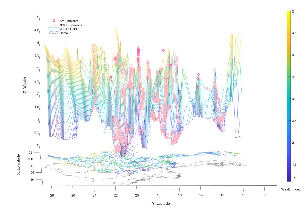
Aerial luminosity, which is consistently available and not constrained to a specific scale, is a robust proxy for regional needs at a granular level. Villages that shine brighter and with more community capacity than needed also tend to receive larger aid amounts in Myanmar.
In the Republic of Congo, Machine Learning combined with spatially-referenced features improves the targeting of social safety net programs and poverty reduction. Twitter, social media, and geographic features from OpenStreetMap are used as a proxy for poverty, as they are correlated with wealth. Sub-national transfer studies such as this allow policymakers to make precise and intuitive allocation decisions. The combination of geo, Twitter features, and daytime satellite features outperform any of our unimodal approaches in predicting poverty.
The significance of these projects is that they provide richer, actionable contexts to policymakers and researchers. They address the issues of data sparsity while developing fundamental geo data sets and infrastructure that government and development partners can use.
Her team works directly with key development institutions in creating poverty indices and designing social protection programs. Some key stakeholders include local government entities (e.g., Zambian Government Ministries, Institut Géographique National), NGOs (e.g., Innovations for Poverty Action), international organizations (e.g., World Food Program), private sector corporations (e.g., Microsoft), and an interdisciplinary team of scholars from around the world. Community engagement is also pivotal to our research in assessing context-aware and intuitive poverty measures. In our endeavor to understand the visual signs of poverty, we prioritize insights from local communities. Participatory approach not only enhances the accuracy of our models but also empowers local communities to voice their realities and advocate for tailored social services.
Bio: Dr. Woojin Jung is an Assistant Professor at Rutgers School of Social Work. She is also a core faculty member at Rutgers Global Health Institute, as well as a faculty affiliate of the Rutgers Urban and Civic Informatics Lab at the Bloustein School of Planning and Public Policy.
For additional readings on poverty alleviation, please consult the following sources.
Relevant Publications
- Announcements for AI funding Jung, W. (2023, submitted). Data Science and Social Work, A. Farmer (Ed.) Encyclopedia of Social Work, Oxford University Press.
- Bukhari, M. H., Shad, M. Y., Nguyen, U. D. T., Trevino, J. A. Jung, W. C., Haque, U, (2023). A Bayesian spatiotemporal approach to modeling arboviral diseases in Mexico, Trans R Soc Trop Med Hyg 2023; 0: 1–9, https://doi.org/10.1093/trstmh/trad064
- Jung, W. (2023). Mapping community development projects: Spatial analysis in Myanmar. World Development. 164. https://doi.org/10.1016/j.worlddev.2022.106124
- Jung. W. (2022). The discrepancy between two approaches to global poverty: What does it reveal? Social Indicators Research. https://doi.org/10.1007/s11205-021-02866-6
- Jung, W. (2020). Two models of community-centered development in Myanmar. World Development, 136. https://doi.org/10.1016/j.worlddev.2020.105081
- Jung, W. (2020). Using data science to strengthen the social safety net: Predicting risk for Medicare and Medicaid insurers. Journal of Governmental Studies. 26(2), 29-61. [In Korean; Abstract In English] https://dx.doi.org/10.19067/jgs.2020.26.2.29
In the News
- Rutgers Research Feature: Focus on Faculty with Assistant Professor Woojin Jung
- Assistant Professor Woojin Jung Receives Research Council Award
- Assistant Professor Woojin Jung Receives Microsoft Azure Grant
- “Development Engineering Scholar Woojin Jung Finds Significant Discrepancies in Global Poverty Measures” in Blum Center for Developing Economies.
